


Bayport geography
The layout of the town of Bayport is richly described over the course of the series. Based on these descriptions, guest contributor Kirby E. Rasch (email: kirbyr6557 at aol dot com) has created the incredible map of Bayport shown below, which contains many details that will be familiar to readers of the series. Click the thumbnail to view the full-size map, and scroll down to read Kirby's insightful essay on the geography of Bayport and the creation of the map.
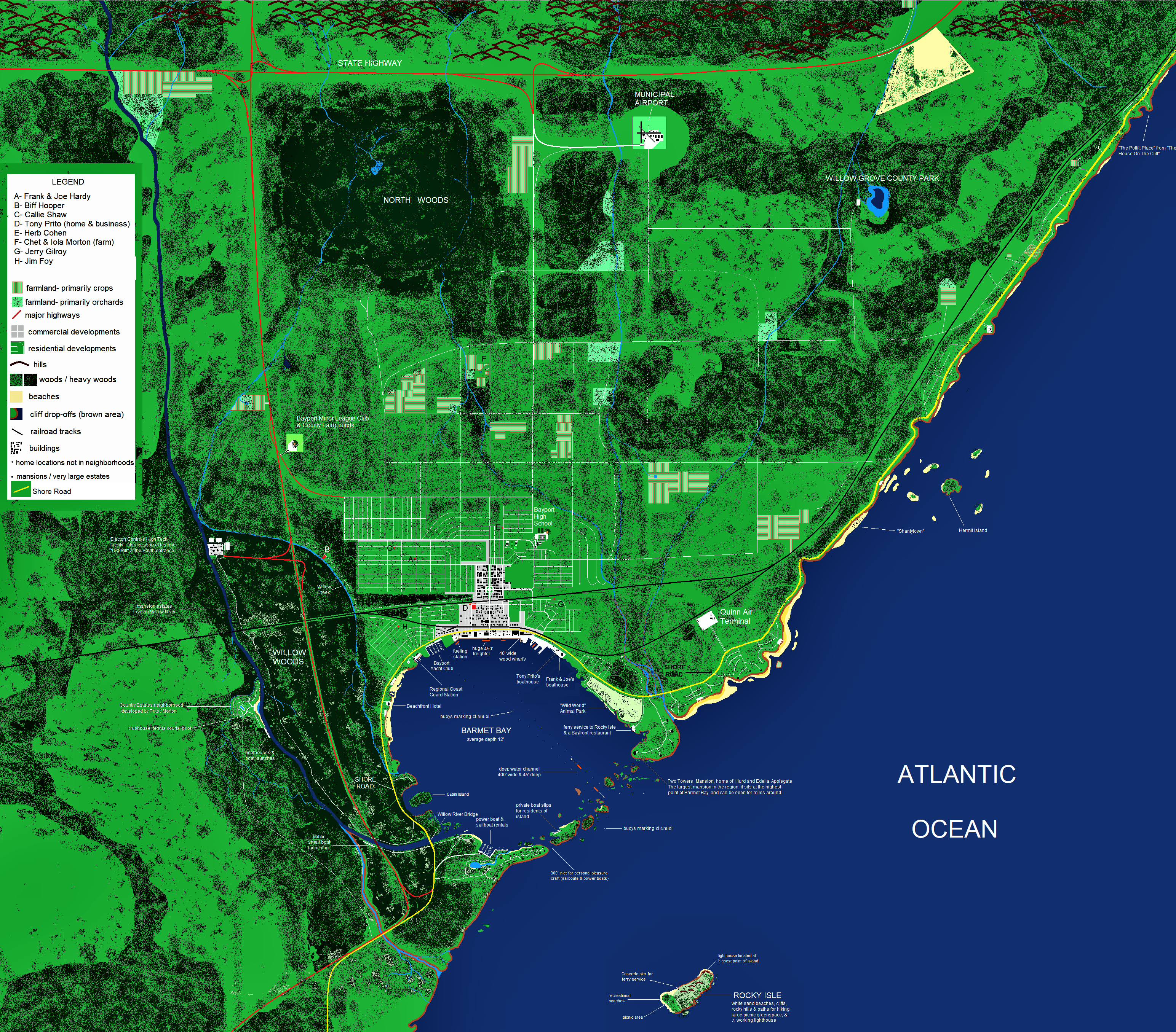
HOW I CREATED THE BAYPORT MAP by Kirby E. Rasch
PRELUDE
First, before getting to the map, some background on the city of Bayport since it affects the map:
Bayport is a thriving small city with 50,000 permanent residents inside its borders, and perhaps anywhere from twice to three times that number on any given day when you include those residents who live just outside city limits, vacationers, and short-term Harbor workers.
The City Planners have done an excellent job in finding the balance between making Bayport attractive to both commerce and quality of life. There are not only a number of Federal facilities, hi-tech companies, and a deep water Port, but also a wide variety of recreational activities for residents and visitors alike to enjoy. Ships coming and going are carefully monitored for leakage and spills since the Bay is a huge draw for vacationer's dollars. The airport can accommodate smaller passenger jets, but for international travel one needs to make a short trip to New York City.
The median income in the Greater Bayport Area is well above the National average, placing it in the top tier of cities in terms of wealth. Some of this is from "old money", but a growing number of well-to-do citizens are transplants there. But this wealth attracts criminals as well, so the police and Coast Guard stay busy. All of these reasons are probably why Fenton decided to move his family here after he early-retired from NYPD.
CHALLENGES OF CREATING A BAYPORT MAP
Before I tackled this project I first looked to see if there was already a comprehensive map out there on the Web that paid attention to scale. I mean, why do this if it already exists? Unfortunately, of the maps I found, only a few are any better than simple hand-drawn diagrams. And none of them gave a rip about scale! The most egregious example of this was a map that showed other towns dotting the coastline all around the Bay, as if it were fifty miles across. Imagine driving on Shore Road around this small Bay and entering and quickly exiting a new town every minute.
Which leads to my next issue: dealing with the size of Barmet Bay, or lack of it. It's listed most often as three miles from the ocean to the docks of Bayport's harbor. One reference says five miles. I wish they had never designated a hard number to it's size, because that is a very small Bay either way. But since the various writers never had to concern themselves with scale they could make the bay seem as big as they wanted to fit their story lines.
For example, in one story a seaplane took off in the Bay without hindering any boats or ships. A seaplane requires anywhere from 2300' to 3600' to take off from water, and a mile is 5,280'. That means that the plane needed perhaps half a mile in a straight line with no obstacles randomly crossing its path to make that take-off in a very crowded Barmet Bay.
Since Barmet Bay contains a deep water harbor with large freighters coming and going at all hours, pleasure craft (sail and motorized), beaches, ferries, and a Coast Guard station, I had to grow the Bay as much as I could without getting too far away from the spirit of the setting. So... I fudged a little bit because it was literally impossible to place all the items mentioned in the books along the coast of the bay. I didn't go crazy and make it ten miles from Port to Ocean, but it's slightly bigger than three miles. That gave me more "wiggle room".
THE HARBOR
Barmet Bay's Port is consistently written into the books as a major one, which means it would be in the top fifteen or so in the United States in terms of tonnage. It can accommodate the same freighters that come down from New York City's port, which could be up to 450' long, and the Port is always described as "busy".
To allow for the displacement of these Freighters, the Port has a deep water channel, which I place at forty-five feet deep, typical for a major port. By the way, the average depth of the rest of the bay has been listed in a Wikipedia article as twelve feet, a realistic depth for a bay. (The much larger Galveston Bay is only an average of ten feet deep, which surprised me.)
The Port in Barmet Bay takes up a significant amount of the waterfront, and is connected to the commercial areas of the city itself and the railroad lines. There are 40' wide wooden wharves along the water for the loading and unloading of cargo, with a vast open concrete concourse behind them that houses warehouses, cranes, trucks, forklifts, and the office buildings associated with the working of a Port. It's a 24 hour-7 days a week place, although it gets quieter at night.
A spur from the railroad dips down to service the entire Harbor area. It then curves back up to join the main line. There is one short spur that backs up to allow for cars to be dis-joined from the rest of the cars.
DOWNTOWN
The lower section of downtown that's connected directly to the Port tends to be somewhat older, with a number of low-rent warehouses, bars, offices, apartments, and empty buildings. The books often describe this area as where many criminals and questionable characters hang out.
If you move further North across the railroad tracks you come to the upscale part of downtown that we are familiar with from the books. It has newer, modestly taller buildings and a beautiful Town Square. The police station, main fire station, prestigious law firms, public library, thriving businesses, and most banks are located in this section.
Surrounding the downtown area are the various subdivisions where many of the main characters live. Frank and Joe Hardy ('A' on the map) live in a large corner house in one of the older upper-middle income neighborhoods, not far from downtown.
Their high school is shown just beyond the subdivisions to the East, with its football and baseball stadiums depicted as well. The Middle school and Elementary schools never figure into the series but I placed them close by the high school since school districts in small cities often buy large parcels of land and put all the schools on it in order to centralize everything and save money.
If I had a realistic choice I would have tilted all of Bayport more to the left along the coast as you look at the map, but given the limitations of BitMap, diagonal lines are far more time consuming to place than vertical / horizontal ones. And there were thousands of those lines needed for the streets, buildings, and other constructs so I did the best I could on that score.
HARDY FRIENDS
Before we get back to the map in general, this is a good place to list where Frank and Joe's closest friends live:
"Biff" Hooper (B) lives in a "country estate" type of neighborhood where all the over-sized shaded lots slope down to a creek. He has a mastiff and bloodhound and this property gives them both plenty of room to romp around. Remember the hilarious moment when the huge mastiff Tivoli ran around and single-handedly destroyed a picnic party held on their property? So it's a big lawn. Down at the creek they have a dock where Biff keeps his boat 'Envoy' tied up in the water.
In one story Biff comes up to the Hardy's home on foot, walking his bloodhound Sherlock. It wasn't treated as an unusual event, so he must do this from time to time. Traveling by street would be a very long walk since my map shows that Biff's country neighborhood and the Hardy's neighborhood are not connected in any way with many turns along the way. But -- if Biff cuts through some woods across the street from his house he can access the far west end of Frank and Joe's street and walk right down the four blocks to their house. I can easily imagine Biff doing this, so I put in a trail through the woods in question. He's probably not the only one who uses it. The Hardys might use it themselves if on foot or on their motorcycles.
Frank's girlfriend Callie Shaw (C) is mentioned by Frank as being only a few blocks away from the Hardys, and "on the way" to the County Fairgrounds, so that's where I put it. Even though Callie is a major supporting character, there really isn't much in the books that describe her home or where it is, other than that.
Tony Prito's home (D) would probably be adjacent to their family business property, a leading construction and building company. And that would be in a commercial location. So he's shown as living on the outskirts of lower downtown, but in a very nice home since his father is a successful small-businessman in Bayport who specializes in home remodeling and construction.
Tony works for his dad, delivering lumber and other building goods around town "in one of their trucks", which tells me that they have multiple business vehicles, requiring a large piece of land for their trucks, lumber yard, and other construction equipment. That is depicted across the street from their home.
For Phil Cohen (E) there's no reference as to where he lives that I can find, so I just put him in a neighborhood in a different area of Bayport since they never say he lives close to the Hardy's home, as they do with Callie. Phil became a more central character in some of the later stories, where he did assignments for Frank and Joe, and that he was a gifted musician who specialized in piano, but there wasn't anything there to tell us where he lived.
Chet and Iola Morton (F) have many reference points for me to use for my map. They live on a smallish farm, anywhere from a mile to three miles North of Bayport city limits. The farm has a roomy two story farmhouse and barn, both set back from the road. They also have an in-ground pool behind the house where Chet practices with his scuba gear.
Beyond the house and grounds lies the large areas of land reserved for crops, an orchard (which is where Chet probably gets all those apples!), and open fields. It was in those open fields that most activities take place in the stories. The Hardys trained their hawk there and many picnics and parties are held out there as well. There is also a small pond in the open field that freezes over in winter. It's large enough for all the Morton's friends to ice skate on, which they do. The Morton's land borders on heavy, almost impenetrable woods to the South where criminals were hiding out in one story.
Although the Mortons live on a farm, they really aren't that involved with the running of it, apparently. Mr. Morton is a full time real estate agent with a busy office in downtown Bayport and has partnered with Mr. Prito on various building projects, including a new neighborhood on Willow River. He is not really a farmer, per se.
I presume the Mortons hire out most of the serious farm work, since when Chet does any it's usually a punishment, and Viola hangs out with Callie 24-7 when she's not mooning over Joe. Mrs. Morton is a housewife, and every time the Hardys drop by she is in the house not out on a tractor. My guess is, the farm is just an excuse for the Mortons to live outside the city and enjoy a country atmosphere in which to raise their children. They're probably happy to just 'break even' on the operating of it.
Jerry Gilroy (G) is a minor character, only appearing in a few books. The only thing I know about him is he loves playing baseball, which tells me nothing about where he lives. Like Phil Cohen, I just stuck his house somewhere that wasn't near anyone else.
Jim Foy (H) is another minor character but I have a bit more information about him. He seems to be from a well-to-do family with connections to New York City boat-building and sales, since he was able to access a Chinese Junk through his uncle for the Hardys and their friends to purchase. Admittedly, this is not much to go on. So I put his home in a newer neighborhood close to Barmet Bay.
OTHER RECURRING CHARACTERS
Chief Ezra Collig - lives in a house just off of Shore Road heading out of town.
Sam Radley - lives in a nice apartment with his wife in a high-rise (high rise for Bayport) downtown apartment building.
Oscar Smuff - a pathetic wannabe cop / P.I. He lacks the skill and discipline to do either one and is transparently jealous of the Hardy's success. He lives in a small house in a less prestigious area of town. Oscar appears in a number of stories, usually as comic relief.
Jack Wayne - the Hardys' pilot. He has his own plane, the Skyhappy Sal, and often flies the Hardys as they work on a case. He is a stalwart person too, ready to fight in their cause if need be. But there's nothing about where he lives. Perhaps he lives up North close to the airport?
Hurd & Adelia Applegate - They appear in not one, but two Hardy Boys books that I recall, so they are worth mentioning. They live in a huge old palatial mansion -- the biggest in Bayport -- that overlooks all of Barmet Bay and the Atlantic Ocean. It's a famous landmark so I single out its location on the map.
TWO MAJOR ROADS
Now back to the map. There are two critical thoroughfares related to Bayport. The highway and Shore Road. The Hardys often drive out to the highway (depicted in red) on their way to places and cities far enough away from Bayport to make it practical to use it. The main highway cuts across the top of the map East to West. A second highway crosses the first one, with one leg heading North and the other dipping down South just outside of Bayport. I show it cutting through Willow Woods because one story specifically mentions it doing that. That makes sense, because it would allow for people to exit North of the Woods to enter Bayport, or continue down to follow along the Atlantic Coast on another highway, leading through other towns South of Bayport.
The other major artery of transportation is Shore Road. It does exactly what the name implies. It follows the shore of the Atlantic coastline wrapping around Barmet Bay along the way. Shore Road is the single most important roadway in the Hardy Boys stories so I highlight it in yellow so it will stand out. The actual road isn't yellow, of course, and neither is it nearly as thick as I depict it. Most of the stories refer to it and it even has a book named after it, The Shore Road Mystery. It's on the cover of a number of Hardy Boys books as well. In some places it's a well maintained road, but in others it's downright scary, becoming narrow with sharp hairpin turns and placed right on the edge of the cliffs leading down to the Atlantic Ocean.
Most of the stories regarding the Shore Road are placed East and Northeast of Bayport. That's where the beaches are that the Hardys and their friends enjoy swimming at. It's also close to where Shantytown, Hermit Island, and the new Federal Observatory are at. It's where the dirigible airfield is and where the "Spider-Man" came up the cliffs on the cover of one book. And it's where the secluded "haunted" Pollitt Place is, from The House On The Cliff, shown at the furthest point Northeast on the map. So it's a busy roadway!
North of Bayport, across the main East-West highway, are where the hills start. Some of the hills are bare, some are covered in forest, and many streams that end up in Bayport start there. If you keep going North you'll get to Skull Mountain and the new reservoir, but I didn't go that far.
Just South of the highway is Bayport's airport. It's small compared to major cities, but multi-passenger planes can land there on its longest runway. The airport is modern and well kept because Bayport receives a large influx of tourists and vacationers who own summer homes there. Also, as mentioned in the Prelude, Bayport is a wealthy community by and large, so many residents who travel to far-away places on vacation don't want the inconvenience of having to drive to New York City.
I think one can use Bayport's airport to travel anywhere in the continental United States. But it's not referred to as an international airport. When the Hardys fly across the Atlantic to England or Iceland or wherever else around the world, they go to New York City to fly out. Of course this doesn't stop Jack Wayne from flying them in his airplane to Mexico or out West.
The North Woods is supposedly haunted and have wild dogs or wolves. It's only a couple of miles North of the Morton's farm, but Chet stays away from it because of the rumors. He entered it in one story only due to the coercion of his best friends Frank and Joe. Aside from the stories of haunting and wild dogs, it is also rarely explored by residents of Bayport because it's so densely packed with trees. It's the thickest woods in the Bayport area. This is why criminals used it as their base of Operations in one story. Deep into the woods is a large lake, but not too large for Frank and Joe -- both excellent swimmers -- to swim across, which they did.
Willow Grove County Park is only mentioned in one story that I could find. It has a lake in the middle and heavy woods just off from the picnic areas. It was in these woods that Chet's stolen jalopy "The Queen" was found, thanks to Fenton Hardy's suggestion that the boys look there.
Bayport has a Minor League baseball team, the Bayport Bears, who play in a baseball field that is also on the County Fairgrounds. Both of these points of interest figured into a couple of stories.
Willow Woods, a densely wooded area outside of Bayport is mentioned in many stories. It's not as densely packed as the North Woods, but it's still a very thick forested area. Although a freeway cuts through it, most Bayporters follow Shore Road around the Bay and take Willow Road just before you get to the Willow River Bridge, a major landmark in the Bay. Willow Road is a country road, narrow and unpaved, with the woods on the East and palatial estates on the West, which lead down to the River itself.
More than one of these estates figure in Hardy Boys stories, as does Elekton Controls, the new High Tech corporation based far up the road, fronted by an historic Old Mill that has been kept in excellent condition by Elekton.
It makes sense that a major corporation wouldn't depend on a narrow country road as its only means of access, so I created a spur from the highway which takes you directly to the private grounds of the company from both North and South.
Also on the shores of Willow River, Mr. Prito and Mr. Morton partnered to build a new subdivision. I placed it on the West side of the river so it wouldn't get in the way of all the river-side mansions along the East bank.
BACK TO THE BAY
Barmet Bay is a multi-function Bay. Aside from the Port, it's also geared by the town leaders to be a draw for tourism, which has been a very successful plan. Sailing, boating, lots of beaches, some fishing, various hotels and motels that are usually packed with vacationers and short-term Port workers.
There are several noteworthy landmarks around the Bay that are worth mentioning. The Shore Road goes over the wide mouth of Willow River close to where it empties into the Bay by means of a decorative bridge that can be seen clear across the other side of the Bay.
Up the shore from the bridge is "Cabin Island", the largest of the islands inside the Bay. In an adventure concerning Cabin Island, the Bay was frozen over and the Hardys used their ice boat to access it. On foot they had to head due West crossing over three hundred feet of slippery ice to reach land (the length of a football field) then trudge through heavy woods to reach Shore Road. Going by foot North and South of the Island was impossible, since both shores are bordered with high cliffs.
Up from that is "Sandy Beach", a hugely popular tourist attraction for out-of-town visitors. Most locals don't use it, preferring the beaches North on Shore Road that face the Atlantic to avoid the crowds. Sandy Beach isn't a white sand beach, but it's close. It has various concessions and equipment rentals, as well as a hotel.
Up from Sandy Beach is the Coast Guard Station. This is a regional station so it covers a territory on either side of Barmet Bay of at least a hundred miles (200 miles total), and out to the twelve mile limit of the Atlantic -- international waters.
Bayport Yacht Club is next, where Frank and Joe go to re-fuel The Sleuth at the dock, and have a quick bite to eat in the dining room which faces the Bay.
Next around the Bay is the huge Port, which has already been described. Several 'blocks' down this concourse is where town residents have their boathouses, including Tony Prito and the Hardys. The Hardy's boathouse is somewhat separated by the others on both sides, with the closest structure to them being a small security shack. That's a good thing since it seems to get blown up or set on fire on a regular basis!
"Wild World" Animal Park is next as we move a round the coast. The writer of Sting Of The Scorpion didn't do me any favors by placing this huge park right on the shores of Barmet Bay. Something like this would usually be located on the outskirts of a town, far from the general population. That way people don't hear the sounds of the animals all hours, and if a lion escapes it's not fifty feet from it's next human meal. But since he stuck it inside the Bay on the coast, I stuck it inside the Bay on the coast. Sigh...
Next down the coast is the Ferry Service that takes residents and tourists out to Rocky Isle, an immensely popular place to spend the day some miles out in the Atlantic Ocean. The parking lot for the Ferry also has a seafood restaurant with windows facing the Bay.
The last major landmark is Two Towers, the huge mansion where Hurd and Edelia Applegate live. It sits alone on a bluff at the highest point of land surrounding the Bay.
Protecting the Bay from the rough waters of the Atlantic are horseshoe-shaped peninsulas that jut out on both sides of the Bay. Then there are a number of small islands between these two peninsulas that add more protection. There are a number of inlets, the two most prominent ones being a 300' one reserved just for pleasure craft and a 650' one for all traffic, but Freighters have the right of way since this marks the beginning of the channel.
The Bay has buoys that are evenly placed to mark where the forty-five foot depth of the 400' wide channel lies. The channel is much larger in area at the wharves to allow for the huge freighters to make their wide turns to leave, sometimes pulled by tugboats.
OUTSIDE THE BAY
Rocky Isle has been mentioned, but not in detail. It's a large island in the Atlantic that has a little something for tourists and residents alike. It has true white sand beaches, a large green-space for picnicking, various food concessions and rental booths for everything from air mattresses to picnic supplies to hiking gear to sunglasses. It has paths in the high rocky hills that are fun for hikers to trek through. It also has a working lighthouse at the highest point on the island, with a full-time Keeper who lives on the island. Visitors can climb the winding stairs of the lighthouse during certain hours. Caves are located on this side as well and figure into one book.
Map and essay copyright © 2022 by Kirby E. Rasch